Wikimapia.org


Wikimapia.org& blog stuffJanuary 18, 2010

It should be fairly clear that I haven’t posted on Wikimapia in a long time, but I am glad you still come here and have found things useful. There are still various links on the right, including a donate button, please feel free to send a few bucks my way! :)

For more up to date Wikimapia information, there are a few places you should be visiting:

  • Wikimapia Documentation: Wikipedia style information about Wikimapia.

  • Wikimapia Forums: Here people can discuss all matters Wikimapia.

  • Wikimapia Blog: The Official Wikimapia Team Blog


  • And just to be clear (as I still get LOTS and LOTS of comments about this), I am NOT an employee of Wikimapia and cannot do anything to help you with someone saying anything mean about you. Sorry.

    If you would like to visit me at my MattJones Wikimapia Profile.

    How To& Wikimapia.orgMarch 24, 2007

    Seattle's Green Lake in Polygons

    Alexandre has announced that polygons have been introduced to Wikimapia! This is a great addition! Currently only registered users can use the polygons and they can only be added to existing places. Also, they don’t change the place marker, but show up when you roll your mouse over the location. This is definitely a step in the right direction!

    The sixth edition of my how to use Wikimapia shows you how to turn a place marker into a polygon that fits your location. (Images are clickable for larger versions.)

    Click here to continue reading this post…

    Wikimapia.orgNovember 18, 2006

    Wow, it has been a long time since I have posted! Running 3+ blogs is time consuming! I hope people have been using Wikimapia a lot! There have been a number of updates to Wikimapia’s service and since some of them were mentioned at their official blog, I would address them now as well.

    Wikimapia Profile
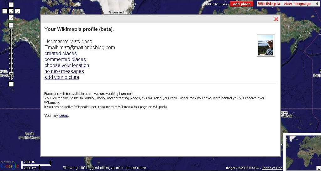
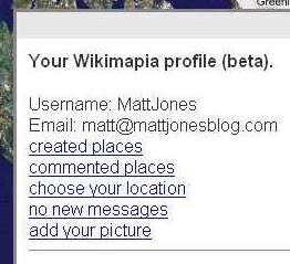
Registration: Do it. Even if you don’t see the immediate benefits or features, might as well do it now as they are constantly adding features and capabilities. To register, click the “WikiMapia” menu and select “login/register” and just follow the steps. It takes some time for the registration to go through, so just be patient. One you are registered, you will have a basic profile (I am assuming that down the road you will be able to make more modifications of it). In that profile you can add a picture and pick your location. You will also be able to see places you have commented on and places you have created. Message sent to you will also be indicated here. [ADDENDUM: I am NOT saying register at this blog, I am saying register at WIKIMAPIA! Feel free to register as a user here if you want, but it won’t get you much!]

    Messages: when someone leaves a comment and is registered, you have to ability to send them a message through the system.

    Wikimapia is approaching 2 million places marked!!

    Registered users can now delete places and pictures that have been added. It is also now possible to “semi-protect” articles so it is more difficult for people to edit the info for the protected place.

    Wikimapia (and my blog too!!) are still getting requests for updates. There are two issues here. 1) Wikimapia has NO CONTROL over the map imagery. AT ALL. NEITHER DO I! Hehe, really, see my Matt’s Wikimapia Blog FAQ #4 for the reasons. 2) If it is the place information that needs to be updated, YOU update it! This is a Wiki site, that means the users have the power to edit things if they are needed.

    Another thing that the Official Wikimapia Blog noted was the fact that when Google Maps updates their imagery it sometimes gets shifted. I am not sure why this happens. I am assuming that they know it happens, but that we just have to deal with it. I noticed this when looking down at Cape Canaveral in Florida. Solution? Just change the locations. If you open up the place that in slightly in the wrong position because of the shift (or for any reason really), go to the “Menu” menu and select “move or resize” (I believe this will only work for registered users). Then just make it fit the correct location! Done and done.

    Some reminders: Add photos to places! I think it is awesome to have a satellite view of something but then to also see what it look like from other vantages. Add photos! Do it! heh. Edit places. Just because a place has already been created doesn’t mean they are complete or correct. If you know something about the place, check it out, correct the information that is there and add to it if you can. Add websites to places. Yes, add Wikipedia links (they now have a dedicated spot), but also add webpages or news stories about the place. Anything that can add to the information! Stop adding stupid places! I don’t need to know where your home is, really. Yes, you technically can add it under “private places”, but don’t. Also, don’t add spam, inappropriate places, all caps places… you get the idea. They will just be rejected or deleted and there is a good chance you will get your IP blocked. So just stop it.

    Wikimapia will also be adding new shapes (so your location doesn’t have to be rectangle) and different colors for different types of places. There is always lots more to come! If you want to see the discussion about development and other issues there are three places to check out: Wikimapia @ Wikipedia Talk Page, Alexandre Koriakine @ Wikipedia Talk Page, and Wikimapia @ Meta.Wikimedia.

    Wikimapia.orgOctober 1, 2006

    Google EarthAwesome news from Alexandre and Evgeniy at Wikimapia: They have created a Google Earth layer that will allow you to see Wikimapia places! Wikimapia now has more than 1.5 million places marked with new ones being added all the time! This new merging will allow you to see them all! [UPDATE: Sorry if things are slow around here, I am poor so don’t have expensive servers and the Digg Effect has caused some slowdown and outages (I don’t think the problem is with bandwidth, I think it is with the amount of SQL queries). Please be patient!]

    As I noted in my Wikimapia vs. Google Earth post, one of the cool things about Google Earth is its very flixible navigation. Like Google Maps, Wikimapia is limiated to N/S, E/W movement (with North always at the top) and a perpendicular orientation. Google Earth allows users to have free range of motion (not to mention easy zooming). Now, by loading Wikimapia’s Google Earth kml (Keyhole Markup Language) file you can add the Wikimapia information layer to Google Earth!

    Now Wikimapia can take advantage of Google Earth’s added functionality. Aside from the flexible navigation, user added layers (often with higher resolution images or other interesting information) can be used alongside Wikimapia.

    Ready to try it out? Click here to continue reading this post…

    Wikimapia.orgSeptember 26, 2006

    I have read some discussion about the relative benefits of using Wikimapia compared to Google Earth. My first thoughts on the subject: this is comparing apples to oranges. UPDATE! Check out my post: Wikimapia Invades Google Earth! Wikimapia just released a new Google Earth layer that will allow you to use all the cool features of Google Earth right along side the awesomeness of Wikimapia!

    First let me go over the similarities. Both applications use the same imagery. Google Earth, Google Maps, and Wikimapia all use the same satellite / arial photography so the resolutions (amount of detail) will always be the same (there has been some indication that sometimes Google Maps will get the imagery sooner than Google Earth, but by and large, it is the same). Both applications have the ability to allow users to add information about various locations (but the do this very differently).

    Now let me discuss the differences (some of these will be shown more explicitly in the photograph section further down the post).

  • Wikimapia is web based, Google Earth is program based. All of Wikimapia’s features are accessed directly through your web browser. Google Earth must be downloaded and run from your computer (and so will genearlly be more taxing on your system). Advantage: Personal Preference.
  • Differences in navigation: Wikimapia (as well as Google Maps) moves North and South, East and West and to zoom in and out, the appropriate level is choose from the navigation panel on the left side of the screen. Google Earth has the ability to move in any direction, can zoom in and out using the mouse scroller, and can change the angle at which you are viewing the imagery. Advantage: Google Earth.
  • Dimensionality: Wikimapia views the flat 2-dimensional map, Google Earth projects elevations so there is a more 3-dimensional feel. Advantage: Google Earth.
  • User additions: There is where Wikimapia shines (as it is a Wiki). Wikimapia allows all users to add and edit place locations by “Adding a New Place” which is then reviewed by other users. This is the backbone of “Describing the Entire World.” Google Earth also has a very large user base that can add place marker and descriptors. The disadvantage to Google Earth is that because it is computer based, it must open up a web browser that will then allow the user to put in information (the advantage that Google Earth has here is that the infmoration web page allows for a forum type atmosphere [that Wikimapia is also touching upon with the addition of “commenting”]). The way Google Earth displays the added information can also end up looking very cluttered (images below give good example of this). Advantage: Wikimapia.
  • Peer review: Wikimapia allows users to review “Upcoming Places” which helps reduce the amount of “graffiti” that shows up on the maps. Google Earth does not seem to have this ability. People can discuss the merits of the place marker in that marker’s web page, but regardless of the quality, it will still show up in Google Earth. Advantage: Wikimapia.
  • I am sure there are other similarities and differences, but those are what I came up with off the top of my head. And really, I shouldn’t be saying one has the advantage over the other, both work very well but, depending on what you want to do, each will work better in different situations. Let me know if you need me to clear any of this up.

    Here are some screen captures that help show the differences (images are clickable for larger versions).

    Click here to continue reading this post…

    Wikimapia.orgSeptember 21, 2006

    Earlier today Wikimapia added a few more features. The biggest of those features is the addition of GPS Capabilities. These new features will allow users with a GPS device to have their present location marked on Wikimapia. This will allow those users to check out what places are near to their location.

    There are two ways you can add this functionality. Click here to continue reading this post…

    Next Page »


    Warning: fsockopen() [function.fsockopen]: php_network_getaddresses: getaddrinfo failed: Name or service not known in /home/content/m/a/t/mattblog/html/wikimapia/wp-content/plugins/wp-shortstat2/wp-shortstat.php on line 128

    Warning: fsockopen() [function.fsockopen]: unable to connect to udp://whois.happyarts.net:8000 (php_network_getaddresses: getaddrinfo failed: Name or service not known) in /home/content/m/a/t/mattblog/html/wikimapia/wp-content/plugins/wp-shortstat2/wp-shortstat.php on line 128

    Warning: stream_set_timeout(): supplied argument is not a valid stream resource in /home/content/m/a/t/mattblog/html/wikimapia/wp-content/plugins/wp-shortstat2/wp-shortstat.php on line 129